- 9808563601
- Reg. No.:71796/066/067

Challenging
Budget: Request Price
Duration: 20 Days (Cutomizable Trip)
We will pick you up at the airport and transfer you to your hotel. The rest of the day is free time to explore Thamel.
Meet your trekking guide, discuss the trip itinerary and sightseeing around Kathmandu valley. Free evening to explore Kathmandu.
We travel west from Kathmandu towards Pokhara, following the winding road over the valley rim and down alongside the Trisuli River. This is a busy road and there is much to see. We are also reminded of our journey’s aim; to trek among the mighty Himalaya, with the Annapurna, Ganesh and of course Manaslu ranges intermittently in view. We turn off the main road shortly after Mugling and follow the Dorandi Khola northwards to Gorkha and Arughat Bazaar. Our first nights camp is set beside the Buri Gandhaki river.
An easy walk today along the banks of the Buri Gandakhi river. We enjoy clear views of the Ganesh and Shringi Himal as we pass through numerous Gurung villages before reaching our camp in a small village beside the river at Liding.
Today’s walk follows a trail of constant ups and downs through forest as we continue to head upstream along the Budi Gandakhi. We descend to the wide, sandy riverbed for lunch then continue along a winding mountain path overlooking the river. The forest then gives way to farmland as the valley again opens up and we stop to make our camp.
The Buri Gandakhi gorge is narrow with sheer cliffs on either side and the morning’s trail begins by following a cliff path along the east bank before passing hot springs at Tatopani and then crossing the Dodan Khola. As we begin to climb, the Buri Gandakhi valley undergoes dramatic change, widening considerably and with white sandy beaches at the riverside. The trail then heads up a steep ridge before a long descent to the river. We enjoy a spectacular campsite tonight at Yaru Khola.
A day of relatively easy ups and downs as we follow the river upstream. We cross a number of tributaries before arriving at our camp beside the river at Philim.
Continuing on, we occasionally have to trek high above the river to skirt around narrow gorges that prohibit a path. The trail takes us through pine forest scattered with rhododendron. We make our way to the lower trail which again follows the Buri Gandakhi below the Gurung village of Ngak and camp an hour’s walk past Deng.
We climb initially and then descend to cross a suspension bridge to the opposite bank. There are more riverside undulations and mani walls and chortens may be seen, signs of the distinctly Tibetan territory into which we are entering. The valley trail keeps to the northern bank below the village of Bih. Bih is known for its family of master stone carvers and along the trail today we see flat stones carved with intricate figures and stupas. Just past Bih we catch glimpses of the Shringi Himal and continue along the northern bank of the Buri Gandakhi until we reach the dominantly Tibetan village of Ghap for lunch. We then continue up through the forest densely vegetated with pine and birch to our jungle camp amongst the trees just before Namru.
We descend to cross the Damonan Khola then ascend again along a narrow path through the forest to Namru with its check post then continue through the forest path past small Tibetan villages towards Ligaon. It is likely that we will encounter our first yak today and there is also a troop of monkeys who often come down to the river here to drink. We have uninterrupted views behind us of Ganesh III and IV and Baudha Peak and to our right the Kutang Himal stands high as the natural border between Nepal and Tibet. Before us our first real mountain panorama opens up with the peaks of Himalchuli (7893m), Peak 29 (7871m) and finally Manaslu (8163m).
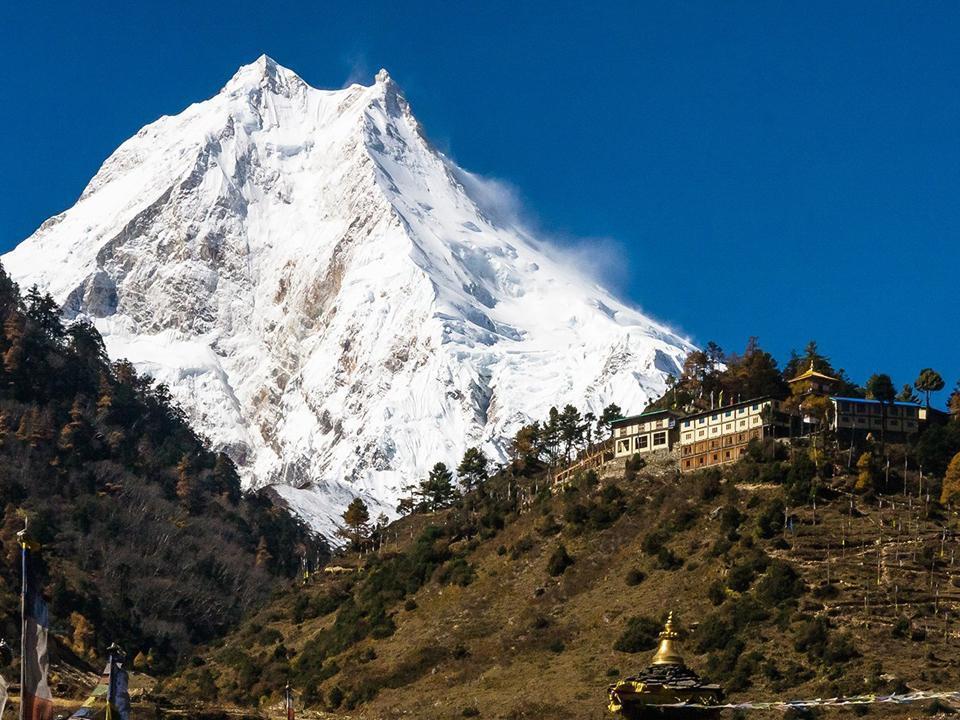
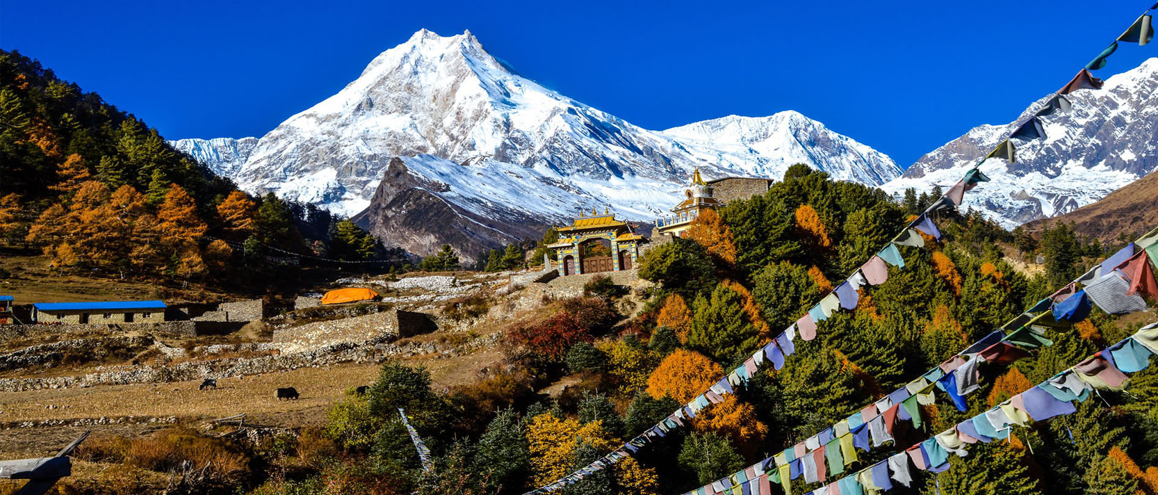
We cut diagonally across a rocky riverbed and climb a small ridge to a clearing. An amphitheatre of snow covered peaks including Manaslu. Manaslu North (7157), Peak 29 and Himalchuli surround us. The valley opens up and we continue along grassy slopes and small ridges which finally gives way to cultivated fields of Sama village. The trail takes us out of the grasslands and into wider territory as we skirt around some glacial moraine then descend to the riverbed. The view of Manaslu is superb today.
Today has been set aside for acclimatisation. There is an optional walk up the ridge below Manaslu to base camp (4500m), approximately 1500ft, in snow, to gain spectacular views of Manaslu, glaciers and lakes.
The trail takes us out of the grasslands and into wilder territory as we skirt around some glacial moraine then descend to the riverbed. Excellent views of the peak of Manaslu today. We soon reach the Tibetan Refugee village of Samdo, a wild place with a substantial village of some 200 permanent residents. Day 14 is a rest day. Relax and enjoy the surroundings or explore Lajyung Bhanjyang valley.
After a couple of stream crossings, the Larkya Glacier appears on the opposite bank. We steadily climb, skirting around the Sarka Khola to camp at a small brick hut at the base of the Larkya La (pass).
Soon after setting off today the unique shape of Larkya Peak becomes visible. The trail upwards is very gradual but at this altitude we take our time. It takes us approximately 5 hours to reach the pass, with the last section becoming quite steep but it is well worth the effort. The mountain vista to the west is incredible – Himlung Himal (7126m), Chap Himal, Gyaji Kang, Kang Guru (6981m) and Annapurna II (7937m). The descent from the pass is very steep across ice and scree as we follow the glacier. Progress is slow and careful but eventually we enter the valley of the Burdin Khola and continue to Bimtang and our camp for the night.
The trail now basically follows the Marsyangdi downstream, before entering a pristine forest of pine and rhododendron which during the spring months puts on a brilliant display of color. This is another day to ensure you have plenty of film in your day packs as the views of the Himlung and Manaslu Himal are again spectacular.
We cross the bridge to the village of Thanje then continue and emerge on the banks of the Marsyangdi Khola. We are now on the main trekking trail, evident by the number of tea shops selling cakes and beer.! It is a long but easy downstream to enter the wide, flat valley and the village of Tal.
Note: Above itinerary can be possible to customize if you want to. And Go on our Add Ons page for trip extensions information.
We drop you to airport for your onward journey. See you again.
| Trip Name | Start Date | End Date | Space Left | Price |
|---|

We provide tourist standard accommodations in city, and this is possible to upgrade in your choice. All the accommodation in the cities and trekking will provided on twin sharing basis. Most lodges now have twin bedded rooms but you should still be prepared to sleep in multi-bedded rooms on the occasional night. Single supplement will be served on request and will cost extra.
During Manaslu Circuit Trek, we can enjoy authentic Nepalese food as well the more common international cuisine (Tibetan, Continental, Italian, Indian, etc.). Breakfast and dinner will be served from the tea-houses or from a lodge menu where we spend the night whereas lunch will be served on the way to the next destination. 3 main course meals will be provided during trekking while only breakfast will be available while in the city.
Autumn (Sept to Nov) and Spring (March to May) are the best seasons for the Manaslu Circuit Trek. The weather is sunny and warm with outstanding views. If you wish to avoid crowds and enjoy some alone time with nature then taking this trip during winter (Dec, Jan, Feb) could also be an another great option.
However, the temperature during winter could be harsh for most guests. Trekking in the Summer or Monsoon seasons (June to Aug) will be affected by rain but the Summer trek could be a boon for a keen botanist.
Packing List
Essential Items:
-Warm Jacket
-Waterproof jacket or poncho
-Mid-weight fleece or sweater
-2-3 Hiking shirts
-1-2 pair Hiking pants
-2-3 Non-hiking shirts
-1 Long-sleeve shirt
-1-2 Pairs non-hiking pants, shorts or skirts
-2-3 Pairs warm socks
-Warm hat
-Sun hat
-Long underwear (for high altitude)
-Gloves (for high altitude)
-Towel (preferably quick dry)
-Day pack
-Hiking shoes
-Sandals
-Sunglasses
-Water bladder or bottle
-Headlamp or flashlight
-Sun screen
-Lip balm
-Personal medications
-Camera
Non-Essential Items:
-Sleeping bag (can rent in Kathmandu)
-Trekking poles (can buy or rent in Kathmandu)
-Rain pants
Leaving items in Kathmandu:
You will be able to leave some of your non-valuable items at your hotel in Kathmandu when on the trek. You do not need to take everything trekking especially since there is a 12 kg limit that the porter will carry for you.
 Your safety is of our major concern while traveling with Mountain World Treks. Please note that your Trekking guide has the authority to amend or cancel any part of the itinerary if it is deemed necessary due to safety concerns. Every effort will be made to keep to the above itinerary.
However, since this adventure entails travelling in remote mountainous regions, we cannot guarantee that we will not deviate from it. Weather conditions, health condition of a group member, unexpected natural disasters, etc., can all contribute to changes in the itinerary. The Guide will try to ensure that the trip runs according to plan, but please be prepared to be flexible if required.
 Terms and Conditions
This agreement applies between you (client) and Mountain Word Treks and Expeditions Pvt. Limited, the owner of this website. Upon booking a trip with us, you are agreeing to be bound to the following Terms and Conditions. Both parties agree to these Terms and Conditions to resolve any legal or other disputes that may arise during the trip.
Payment
Within one week of receiving your trip confirmation from us, a 25% deposit of the total cost of your trip is required. The rest of the cost can be paid upon arrival.
Cancellation by the Client
In the event of the need to cancel your trip, you must contact us as soon as possible. The date on which we receive your cancellation request will determine the cancellation charge.
If you cancel your trip 30 days or more before your departure, you will receive a full refund minus the bank’s service charge and the cost of cancelling services booked. Cancellations less than 30 days before your departure will result in loss of deposit and the cost of the services booked.
The Client is strongly advised to take out trip cancellation insurance at the time of making the booking.
Please note that no refunds will be made if you voluntarily leave a trip for any reason after the trip has begun. No refunds will be made for any accommodation, transport, sightseeing, meals or services not utilized.
Cancellation by the Company
Mountain World Treks reserves the right to cancel any trip prior to departure due to reasons beyond its control (i.e. natural disasters, flight cancellation, consequences of strikes, wars, riots, sickness, quarantine, government intervention, weather conditions). In such a case, Mountain World Treks will refund the trip price or you are entitled to take an alternative trip of the same value within one year of your scheduled departure.
Changes to Your Itinerary
If you wish to make a change to your itinerary please contact us as soon as possible. We will do our best to accommodate your requests. If the itinerary amendment is made within 30 days of the trip departure, there may be an additional cost depending upon our arrangements.
In the case that Mountain World Treks needs to make an alteration to your itinerary we will contact you as soon as possible to discuss alternatives. Sometimes unavoidable circumstances arise that are beyond our control such as flight delays, weather, natural disasters and road conditions that will alter the planned trip. We will work as quickly as we can to make new arrangements that please everyone. Mountain World Treks will not be responsible for the additional expenses incurred from such incidents.
Mountain World Treks does not accept any responsibility for costs incurred as a result of missed international flights, but would assist to make alternative arrangements wherever possible. Because domestic flights in Nepal can often be delayed, we highly advise you to allow extra days upon arrival to and departure from Nepal to avoid having to reschedule a flight.
Price Changes
Due to various external forces, we may need to adjust our costs. We reserve the right to revise pricing under any circumstances. We will notify you if any of your trip costs change.
Passport and Visa
All clients must have a valid passport with at least 6 months validity from return date.
It is your responsibility to ensure that you are in possession of the correct visas for the countries you are traveling to. Mountain World Treks cannot accept responsibility if you are refused entry to a country or places because you lack the correct visa documentation.
Travel Insurance
All clients must have a comprehensive travel insurance package. Your insurance must cover medical, personal accident, helicopter rescue, emergency evacuation, trip cancellation, loss and theft of baggage. Please see our travel insurance page for more information.
Risks and Liabilities
We are committed to providing the best services and take the necessary precautions so that your trip runs smoothly. However, many things are beyond our control.
Some of our trips may be unsuitable for clients due to age, mobility, pregnancy or physical or mental conditions. The client must notify us at the time of booking of any medical, physical or mental conditions which may affect their ability to participate in all aspects of the trip. Failure to notify Mountain World Treks of any such condition may result in trip cancellation and loss of fees.
We are not liable for providing and special facilities or requests of the client unless we have agreed to do so in writing.
Mountain World Treks would not be liable for any injury/health conditions/emotional or other conditions suffered by the client during the trip.
Communication
All communication, unless otherwise stated, should be sent to info@mountainworldtreks.com or be made by phone.
Updating Terms and Conditions
The Company reserves the right to update and amend these terms and conditions at anytime.
 Nepal Visa Information
There are two ways to obtain a tourist visa for Nepal, either at a Nepalese Embassy before arriving or upon arrival at one of the many entry points.
Visa before arrival:
Visitors can visit their closest Nepalese Embassy to apply for a visa. Usually your visa can be approved the same day if it is not very busy. It is possible to fill out the application online before visiting the embassy to speed up the process.
Visa on arrival:
Visas are granted to visitors upon arrival in Nepal. The same process applies to arrival by air and land. Immigration offices can be found at Trivhuwan International Airport in Kathmandu and the following land crossings:
Kakarvitta, Jhapa (Eastern Nepal)
Birgunj, Parsa (Central Nepal)
Belahia Bhairahawa (Rupandehi, Western Nepal)
Jamunaha, Nepalgunj (Banke, Mid Western Nepal)
Mohana, Dhangadi (Kailali, Far Western Nepal)
Gadda Chouki, Mahendranagar (Kanchanpur, Far Western Nepal)
Kodari, Sindhupalchowk (Northern Border)
Visa fees:
US $25.00 or equivalent foreign currency for 15 Days Tourist Visa with multiple entry;
US $40.00 or equivalent foreign currency for 30 Days Tourist Visa with multiple entry;
US $100.00 or equivalent foreign currency for 100 days Tourist Visa with multiple entry.
Renewing your visa:
If you want to extend your visa, you can go to the Department of Immigration in Kathmandu. It usually only takes a few hours and you can fill out the application online beforehand to save time. The visa costs US $30 for 15 days and US $2 for every additional day.
What to bring:
-A copy of your application
-Passport
-A copy of your passport
-A passport size photo
-Cash
 Travel Insurance
To join one of our trips you must have travel insurance. It is your responsibility to ensure that your insurance provides sufficient coverage appropriate for the activities included in the trip. We advice that your insurance covers the following:
Medical expenses
Helicopter rescue
Trip cancellation
Travel delays and missed departures
Loss and damage of baggage
Please print a copy of your insurance information and policy and bring it with you to Nepal.
Many of our past clients have used World Nomads as their travel insurance company.
 Booking Information
Please fill out the form below to book your trip.
Payment
Within one week of receiving your trip confirmation from us, a 25% deposit of the total cost of your trip is required. The rest of the cost can be paid upon arrival.
Deposit payments can be made by wire transfer to our company bank account or through a money transfer company like Western Union.
Company Account Information:
Bank Name: Nepal Investment Bank Ltd
Account number: 01601010023409
Account name: MOUNTAIN WORLD TREKS AND EXPEDITION PVT
Swift code: NIBLNPKT
Bank Address: Ganeshman Marg, Thamel, Kathmandu, Nepal
Website: www.nibl.com.np
Upon arrival, the rest of the payment can be paid by cash or credit card. Please note that there is a 4% service charge for all credit cards. If you prefer to pay in full before you arrive, you can do so through wire transfer.
Symptoms
Altitude sickness is the human body’s reaction to atmospheric pressure and a reduction of the concentration of oxygen present in the air. As you climb higher into the mountains, your body gradually adapts to the reduced amount of oxygen in the air. The appearance of altitude sickness symptoms shows that your body has increased its altitude level faster than it can acclimatize to the corresponding change in atmospheric pressure and reduction in oxygen. In trekking, altitude acclimatization processes are different for each trekker.
Whilst trekking in Nepal anyone can fall ill with high altitude sickness regardless of their body shape, experience and previous mountain trekking experience. There’s no need to fear high altitude sickness, but it’s very important that you know how to avoid it, how to recognize it and how to act correctly in the event that you encounter symptoms of altitude sickness.
In rare cases, symptoms of altitude sickness may begin to appear starting from 2,400 meters above
sea level, but an increased risk of high altitude sickness sets in starting from the 3,500 meter mark. The high risk or mountain zone starts from 5,500 meters. This is why mountain airports in Nepal like Lukla and Jomsom are located at an altitude of 2,700 -2,900 meters.
The primary symptoms of Acute Mountain Sickness (AMS) are:
 -Headache
-Loss of appetite
-Nausea
-Vomiting
-Fatigue and weakness
-Dizziness
-Restless sleep
-Shortness of breath
-Swelling of the face and hands.
Mild altitude sickness symptoms are experienced by about up to 20% of trekkers at altitudes of up to 3,000 meters above sea level.
At extreme altitudes, above 4,500 meters, Acute Mountain Sickness can turn into High Altitude Pulmonary Edema (HAPE) or High Altitude Cerebral Edema (HACE) which are both very serious.
High Altitude Pulmonary Edema (HAPE) symptoms include: serious fatigue, shortness of breath and dry cough, shortness of breath at rest, rapid and shallow breath, frothy or pink mucus possible, gurgling, rasping sound when breathing, pressure, heavy feeling in the chest, restlessness, rapid pulse, possible fever, cy
anosis – blue or gray lips and indescribable lethargy.
High Altitude Cerebral Edema (HACE) symptoms include: powerful headache which doesn’t pass using painkillers, loss of coordination (ataxia), vomiting, apathy, fatigue, indifference, walks as if drunk, behavioral changes, confusion, hallucinations, cramping fits, short-term blindness and numbness or paralysis o
f individual body part.
HACE is the most dangerous form of high altitude sickness. It progresses rapidly and requires quick action to prevent the trekker’s death. You may only have a few hours time to successfully implement rescue measures depending on the degree of seriousness of HACE.
Prevention
Ascending slowly is the best way to avoid altitude sickness. Avoiding strenuous activity in the first 24 hours at high altitude reduces the symptoms of AMS. When trekking above 3,000 meters be sure to give yo
yourself extra days to acclimatize which will allow your body to adjust to the changes in atmospheric pressure and
oxygen. Alcohol and sleeping pills are respiratory depressants, and thus slows down the acclimatization process and should be avoided. Alcohol also tends to cause dehydration and exacerbates AMS. Diamox is a drug that can be taken before you begin trekking to help with altitude sickness symptoms. Please speak to a doctor to learn more about Diamox.
Treatment
The best way to treat altitude sickness symptoms is to descend. With Acute Mountain Sickness it is best to descend at least 400-500 meters or to the previous altitude at which there were no symptoms. With HAPE
and HACE, one should descend immediately at least 500-1,000 meters. Trekkers should rest for a day or two and drink lots of fluids. If sysmptoms have completely disappeared, the trekker can ascend again. If symptoms continue to worsen the victim should continue to descend or be evacuated.
If you have any specific questions about altitude sickness feel free to contact us or find more information at www.altitude.org